
If you’re looking for breathtaking views, challenging hikes, and stunning red rock formations, then Sedona, Arizona is the perfect destination for you. This desert paradise is home to some of the most beautiful hiking trails in the United States. Whether you’re a seasoned hiker or just starting out, Sedona has a trail that will suit your needs. From easy strolls to difficult scrambles, the trails in Sedona will take you through canyons, up mountains, and across stunning vistas. And with over 100 hiking trails to choose from, you’ll never run out of new adventures to experience. So pack your hiking boots, grab your water bottle, and get ready to explore the beauty of Sedona, Arizona on foot.
Cathedral Rock Hike
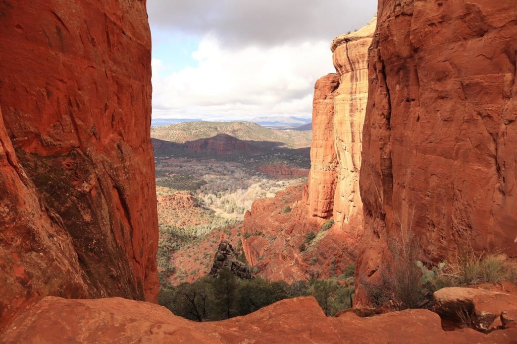
The Cathedral Rock hike is a popular hiking trail located in Sedona, Arizona. The trail is known for its stunning red rock formations and scenic views of the surrounding area.
The hike is approximately 1.5 miles long and is considered moderate in difficulty. The trail starts at the Cathedral Rock Trailhead and follows a series of switchbacks up the red rocks, offering breathtaking views of the surrounding landscape.
As hikers approach the summit, the trail becomes steeper and more challenging. The final ascent requires climbing up a steep incline using hand and foot holds, making this hike more suitable for experienced hikers.
Once at the top, hikers are rewarded with panoramic views of Sedona and the surrounding red rocks. The summit is also a popular spot for taking photos and enjoying a picnic lunch.
The Cathedral Rock hike is located in the Coconino National Forest and requires a Red Rock Pass, which can be purchased at the trailhead or at nearby vendors. It is important to wear appropriate hiking shoes and bring plenty of water and sunscreen, as the hike can be strenuous and the desert sun can be intense.
Overall, the Cathedral Rock hike is a must-do for those visiting Sedona and looking to experience the beauty of the red rocks and stunning views of the surrounding landscape.
| 🤩 Tours & Deals | Check here |
| 🏨 Nearby hotels | Booking.com |
Doe Mountain Trail
The Doe Mountain Trail is a popular hiking trail located in Sedona, Arizona. The trail is known for its stunning panoramic views of the red rock formations and the surrounding landscape.
The hike is approximately 1.2 miles long and is considered moderate in difficulty. The trail starts at the Doe Mountain Trailhead and follows a gradual climb up to the top of the mountain. Along the way, hikers will pass through a variety of vegetation, including juniper trees and desert plants.
Once at the top, hikers are rewarded with breathtaking views of the surrounding area, including views of the nearby red rock formations, the Verde Valley, and the San Francisco Peaks. The summit is also a popular spot for taking photos and enjoying a picnic lunch.
The Doe Mountain Trail is located in the Coconino National Forest and requires a Red Rock Pass, which can be purchased at the trailhead or at nearby vendors. It is important to wear appropriate hiking shoes and bring plenty of water and sunscreen, as the hike can be strenuous and the desert sun can be intense.
| 🤩 Tours & Deals | Check here |
| 🏨 Nearby hotels | Booking.com |
Fay Canyon Trail
The Fay Canyon Trail is a popular hiking trail located in Sedona, Arizona. The trail is known for its scenic views of the red rock formations and the lush vegetation along the trail.
The hike is approximately 2.3 miles long and is considered easy to moderate in difficulty. The trail starts at the Fay Canyon Trailhead and follows a relatively flat path through a lush forest of juniper trees and other desert vegetation. Along the way, hikers will pass by several rock formations and enjoy scenic views of the canyon.
At the end of the trail, hikers can climb up to a natural arch that provides a stunning panoramic view of the surrounding area. The arch is a popular spot for taking photos and enjoying the breathtaking views.
The Fay Canyon Trail is located in the Coconino National Forest and requires a Red Rock Pass, which can be purchased at the trailhead or at nearby vendors. It is important to wear appropriate hiking shoes and bring plenty of water and sunscreen, as the hike can be strenuous and the desert sun can be intense.
| 🤩 Tours & Deals | Check here |
| 🏨 Nearby hotels | Booking.com |
Boynton Canyon Trail
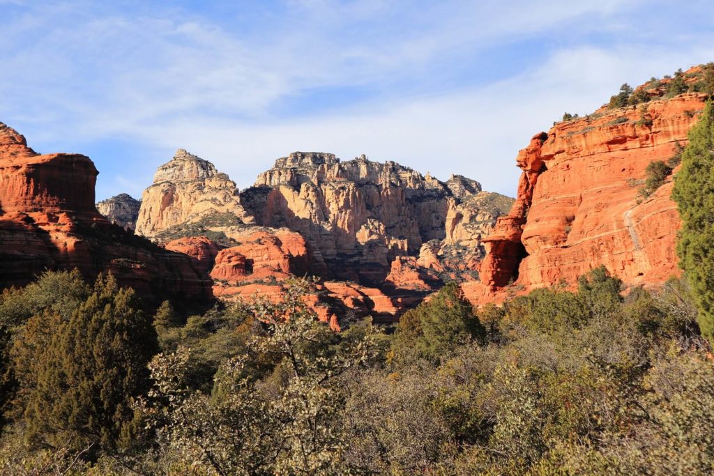
The Boynton Canyon Trail is a popular hiking trail located in Sedona, Arizona. The trail is known for its stunning red rock formations and beautiful views of the surrounding landscape.
The hike is approximately 6 miles long and is considered moderate in difficulty. The trail starts at the Boynton Canyon Trailhead and follows a gradual climb up the red rocks, offering breathtaking views of the canyon and the surrounding area.
Along the way, hikers will pass through a variety of vegetation, including juniper trees, pinyon pines, and other desert plants. The trail also passes by several ancient Native American ruins, including the Boynton Canyon Ruin, which is believed to have been occupied between A.D. 1150 and 1350.
At the end of the trail, hikers can enjoy stunning views of the red rock formations and the surrounding landscape. The summit is also a popular spot for taking photos and enjoying a picnic lunch.
The Boynton Canyon Trail is located in the Coconino National Forest and requires a Red Rock Pass, which can be purchased at the trailhead or at nearby vendors. It is important to wear appropriate hiking shoes and bring plenty of water and sunscreen, as the hike can be strenuous and the desert sun can be intense.
Courthouse Butte Loop
The Courthouse Butte Loop is a popular hiking trail located in Sedona, Arizona. The trail is known for its stunning red rock formations and beautiful views of the surrounding landscape.
The loop is approximately 4.2 miles long and is considered moderate in difficulty. The trail starts at the Courthouse Vista Trailhead and follows a gradual climb up the red rocks, offering breathtaking views of the butte and the surrounding area.
Along the way, hikers will pass through a variety of vegetation, including juniper trees, pinyon pines, and other desert plants. The trail also passes by several other rock formations, including Bell Rock and Castle Rock.
At the end of the loop, hikers can enjoy stunning views of the red rock formations and the surrounding landscape. The summit is also a popular spot for taking photos and enjoying a picnic lunch.
The Courthouse Butte Loop is located in the Coconino National Forest and requires a Red Rock Pass, which can be purchased at the trailhead or at nearby vendors. It is important to wear appropriate hiking shoes and bring plenty of water and sunscreen, as the hike can be strenuous and the desert sun can be intense.
Devil’s Bridge Trail
The Devil’s Bridge Trail is a popular hiking trail located in Sedona, Arizona. The trail is known for its stunning red rock formations and for leading to one of the largest natural sandstone arches in Sedona, known as Devil’s Bridge.
The hike is approximately 1.8 miles long and is considered moderate in difficulty. The trailhead is located at the end of Dry Creek Road and offers limited parking, so it is recommended to arrive early or consider taking a shuttle.
The trail starts with a gradual climb up the red rocks, offering scenic views of the surrounding landscape. As hikers approach Devil’s Bridge, the trail becomes steeper and requires climbing up a steep incline using hand and foot holds, making this hike more suitable for experienced hikers.
Once at the top, hikers are rewarded with stunning views of the red rock formations and the surrounding area, as well as the opportunity to walk across the natural sandstone arch. The view from the bridge is a popular spot for taking photos and enjoying a picnic lunch.
The Devil’s Bridge Trail is located in the Coconino National Forest and requires a Red Rock Pass, which can be purchased at the trailhead or at nearby vendors. It is important to wear appropriate hiking shoes and bring plenty of water and sunscreen, as the hike can be strenuous and the desert sun can be intense.
After reaching the foot of the bridge, you will continue climbing a natural rock staircase that leads to an observation deck with breathtaking vistas. After a short distance, you will arrive at an additional flight of stairs that lead to the bridge.
If you want to avoid dealing with a lot of people while hiking along this well-known path, you should get there as early as possible. At the highest point, there will most likely be a large crowd of people taking pictures on the bridge.
Even though dogs are permitted on the trail, owners should be aware that the final set of stairs are quite steep and may not be suitable for all canines.
Sedona Airport Loop Trail
The Sedona Airport Loop Trail is a popular hiking trail located in Sedona, Arizona. The trail is known for its stunning panoramic views of the red rock formations and the surrounding landscape.
The loop is approximately 3.2 miles long and is considered moderate in difficulty. The trail starts at the Sedona Airport Vista Trailhead and follows a gradual climb up the red rocks, offering breathtaking views of the canyon and the surrounding area.
Along the way, hikers will pass through a variety of vegetation, including juniper trees, pinyon pines, and other desert plants. The trail also passes by several ancient Native American ruins, adding to the cultural significance of the area.
At the end of the loop, hikers can enjoy stunning views of the red rock formations and the surrounding landscape, as well as the Sedona Airport, which is known for its unique location on top of a mesa. The summit is also a popular spot for taking photos and enjoying a picnic lunch.
The Sedona Airport Loop Trail is located in the Coconino National Forest and requires a Red Rock Pass, which can be purchased at the trailhead or at nearby vendors. It is important to wear appropriate hiking shoes and bring plenty of water and sunscreen, as the hike can be strenuous and the desert sun can be intense.
Bear Mountain Trail
The Bear Mountain Trail is a popular hiking trail located in Sedona, Arizona. The trail is known for its scenic views of the red rock formations and the surrounding landscape, including Bear Mountain.
The hike is approximately 5.6 miles long and is considered moderate in difficulty. The trail starts at the parking lot at the end of Boynton Pass Road and follows a gradual climb up the red rocks, offering breathtaking views of the canyon and the surrounding area.
Along the way, hikers will pass through a variety of vegetation, including juniper trees, pinyon pines, and other desert plants. The trail also passes by several rock formations, including the Bear Mountain summit, which offers stunning panoramic views of the surrounding landscape.
The Bear Mountain Trail is located in the Coconino National Forest and requires a Red Rock Pass, which can be purchased at the trailhead or at nearby vendors. It is important to wear appropriate hiking shoes and bring plenty of water and sunscreen, as the hike can be strenuous and the desert sun can be intense.
Bell Rock Pathway
The Bell Rock Pathway is a popular hiking and biking trail located in Sedona, Arizona. The trail is known for its stunning red rock formations and beautiful views of the surrounding landscape.
The pathway is approximately 3.6 miles long and is considered easy to moderate in difficulty. The trailhead is located at the Bell Rock Vista Trailhead, and there is plenty of parking available.
The trail starts with a gradual climb up the red rocks, offering scenic views of the surrounding landscape. As hikers and bikers approach Bell Rock, the trail becomes steeper and requires climbing up a few small hills and navigating some rocky terrain.
Along the way, hikers and bikers will pass through a variety of vegetation, including juniper trees, pinyon pines, and other desert plants. The trail also passes by several other rock formations, including Courthouse Butte and Cathedral Rock.
At the end of the trail, hikers and bikers can enjoy stunning views of the red rock formations and the surrounding landscape, as well as the opportunity to take photos and enjoy a picnic lunch.
The Bell Rock Pathway is located in the Coconino National Forest and requires a Red Rock Pass, which can be purchased at the trailhead or at nearby vendors. It is important to wear appropriate hiking or biking shoes and bring plenty of water and sunscreen, as the trail can be strenuous and the desert sun can be intense.
West Fork of Oak Creek Trail
The West Fork of Oak Creek Trail is a popular hiking trail located in Sedona, Arizona. The trail is known for its stunning scenery, including the red rock formations, crystal clear water of Oak Creek, and lush vegetation.
The trail is approximately 7.2 miles long and is considered moderate in difficulty. The trailhead is located off of Highway 89A, and there is a parking area available.
The trail follows the path of Oak Creek, with several creek crossings along the way. Hikers will walk through a beautiful canyon filled with towering red rock walls, pine trees, and other desert plants. The trail also passes by several natural swimming holes, making it a great spot to cool off on a hot day.
At the end of the trail, hikers can enjoy stunning views of the surrounding landscape and the opportunity to take a dip in the refreshing water of Oak Creek.
The West Fork of Oak Creek Trail is located in the Coconino National Forest and requires a Red Rock Pass, which can be purchased at the trailhead or at nearby vendors. It is important to wear appropriate hiking shoes and bring plenty of water and sunscreen, as the hike can be strenuous and the desert sun can be intense.
Mescal Trail
The Mescal Trail is a popular hiking and mountain biking trail located in Sedona, Arizona. The trail is known for its stunning red rock formations and beautiful views of the surrounding landscape.
The trail is approximately 2.4 miles long and is considered moderate in difficulty. The trailhead is located off of Long Canyon Road, and there is limited parking available.
The trail follows a gradual climb up the red rocks, offering scenic views of the surrounding landscape. As hikers and bikers approach the top of the mesa, the trail becomes steeper and requires navigating some rocky terrain.
Along the way, hikers and bikers will pass through a variety of vegetation, including juniper trees, pinyon pines, and other desert plants. The trail also passes by several rock formations, including the Mescal Mountain summit, which offers stunning panoramic views of the surrounding landscape.
The Mescal Trail is located in the Coconino National Forest and requires a Red Rock Pass, which can be purchased at the trailhead or at nearby vendors. It is important to wear appropriate hiking or biking shoes and bring plenty of water and sunscreen, as the trail can be strenuous and the desert sun can be intense.
Soldier Pass Trail
The Soldier Pass Trail is a popular hiking and mountain biking trail located in Sedona, Arizona. The trail is known for its stunning red rock formations, including the Seven Sacred Pools, and beautiful views of the surrounding landscape.
The trail is approximately 4.5 miles long and is considered moderate in difficulty. The trailhead is located off of Soldier Pass Road, and there is limited parking available.
The trail starts with a gradual climb up the red rocks, offering scenic views of the surrounding landscape. As hikers and bikers approach the Seven Sacred Pools, the trail becomes steeper and requires navigating some rocky terrain.
Along the way, hikers and bikers will pass through a variety of vegetation, including juniper trees, pinyon pines, and other desert plants. The trail also passes by several rock formations, including the Devil’s Kitchen sinkhole.
At the end of the trail, hikers and bikers can enjoy stunning views of the red rock formations and the surrounding landscape, as well as the Seven Sacred Pools, which are a series of natural swimming holes and waterfalls.
The Soldier Pass Trail is located in the Coconino National Forest and requires a Red Rock Pass, which can be purchased at the trailhead or at nearby vendors. It is important to wear appropriate hiking or biking shoes and bring plenty of water and sunscreen, as the trail can be strenuous and the desert sun can be intense.
FAQs
What to wear hiking in Sedona?
When hiking in Sedona, Arizona, it is important to dress appropriately for the weather and terrain. For warm days, wear lightweight, breathable clothing such as a T-shirt, shorts, and a hat. For cooler days, wear layers of clothing, such as a long-sleeved shirt, pants, and a jacket. It is also important to wear sturdy, closed-toed shoes with good grip to protect your feet from the terrain. Finally, don't forget to bring plenty of water and snacks.


